
-

-

-
 PT | EN
PT | EN 
The Brazilian Nationally Determined Contribution (NDC) established ambitious greenhouse gas emissions reduction targets. Using the Brazilian Forestry Code as reference, we describe the challenges Brazil will face to achieve its deforestation and forest restoration NDC commitments in the Amazon biome. This paper proposes a new perspective for public policy focusing on the extent of illegal deforestation and on current land use in the region.
According to data from the National Institute for Space Research (INPE 2022), deforestation has reduced by 85.3 million hectares (Mha) Brazil's 402.7 Mha original Amazon forest cover. The 21.2% reduction has gathered pace since the 1980s. The deforestation rate has varied greatly since measurement began in 1988, peaking in 1995 (2.91 Mha) and 2004 (2.77 Mha). Robust command and control action by the federal government reduced forest clearing by 84% from 2004 to 2012. That decline motivated Brazil to include bold land use targets in its Nationally Determined Contribution (NDC) presented to the 2015 United Nations Framework Convention on Climate Change (UNFCCC) within the framework of the Paris Agreement. Brazil has pledged "to achieve, in the Brazilian Amazon, zero illegal deforestation by 2030 and compensate for greenhouse gas emissions from legal suppression of vegetation by 2030." Brazil further committed to "restoring and reforesting 12 million hectares of forests by 2030, for multiple purposes." The deliberate inaction of the Bolsonaro administration caused forest felling to increase significantly from 2018 to 2022. To regain control over the region and meet its 2015 NDC commitments, Brazil will need sound public policies supported by detailed information on the Amazon biome. This document contributes to this purpose by providing a detailed assessment of the challenges Brazil will face to achieve its zero illegal deforestation and forest restoration goals in the Amazon.
Law 12,651/2012 (Forestry Code) established the legal framework for Brazil's land use policy. The Code governs the private use of land and sets out the proportion of each property's area that can be used for agriculture and livestock farming. A certain proportion of rural properties, referred to as legal reserves, is to be preserved to protect natural vegetation. The Code also prohibits the removal of the natural vegetation on hilltops and near river basins, deemed permanent protection areas (APP) necessary to preserve water resources and to protect the soil. The size of the legal reserve depends on the biome; in the Amazon biome, it corresponds to 80% of each property, except in circumstances specified in statute. Landowners are required to sign compliance agreements under which they commit to restore any APP or legal reserve areas cleared until July 22, 2008. Removal of the native vegetation within legal reserve areas after July 2008 is banned and subject to penalties and fines.
When the legal reserve is smaller than required, the landowner incurs a deficit. Landowners whose properties include native vegetation areas in excess of the legal reserve accumulate surpluses. Landowners with deficits may offset them by purchasing surpluses from other properties within the same biome; this provision creates a market for forest credits.
Compliance with the Forestry Code is essential for Brazil to achieve the emissions and land use targets in its 2015 NDC (Soterroni et al. 2018). That study found that full implementation of the Code will provide most of the 0.90 GtCO2eq reduction in greenhouse gas (GHG) emissions in 2030 compared to the 2005 level Brazil committed to in its NDC. Achieving zero illegal deforestation and restoring the Amazon rainforest are key for Brazil to reduce its emissions. If Brazil fails to enforce the Code to achieve zero illegal deforestation and restore forest cover, Brazil will not satisfy the land use portion of its NDC.
To restore the forest and to satisfy its NDC, Brazil needs up-to-date information on Forestry Code compliance by rural properties. It is then essential to know the native vegetation recovery requirement for each property…
To restore the forest and to satisfy its NDC, Brazil needs up-to-date information on Forestry Code compliance by rural properties. It is then essential to know the native vegetation recovery requirement for each property and the Code therefore requires landowners to self-report the relevant information to the Rural Environmental Registry (CAR). The CAR record for each rural property includes ownership and coordinate details, its permanent preservation area and legal reserve so that the CAR can be used to find landowners in violation of the Forestry Code.
We compared INPE maps with property details in the CAR and INCRA databases to identify illegal deforestation areas and then calculated each property's legal reserve deficit or surplus. We organized deficits by property size and by type of land use to indicate the potential opportunity costs associated with forest restoration. Those hitherto unpublished results will supplement and expand prior studies (Soares-Filho et al. 2014; Rajão et al. 2020; Guidotti et al. 2020; Stabile et al. 2020; Charivari et al. 2021; Igari et al. 2021; CSR 2022). Our purpose is to contribute with the creation of realistic public policies that can restore the forest and satisfy Brazil's NDC commitments.
DATA
We used the databases listed in Table 1 to make an up-to-date and in-depth review of land occupation in the Amazon.
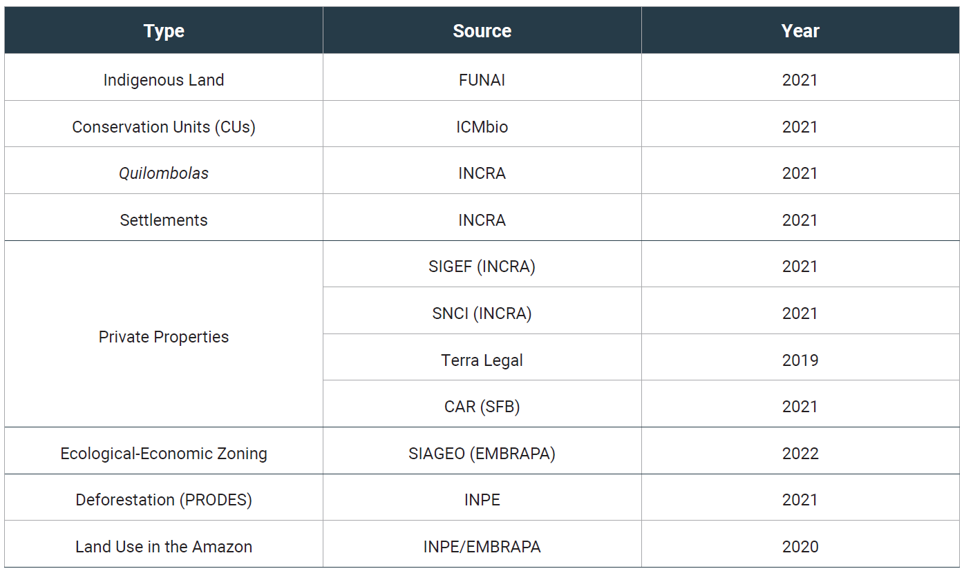
Table 1: Land use and occupation databases. Prepared by the authors based on information provided by FUNAI, ICMBio, INCRA, CAR/SFB, EMBRAPA, INPE.
The National Institute for Space Research (INPE) has since 1988 fed satellite images into the Amazon Deforestation Monitoring Project (PRODES) system to map felled native forest areas in the Amazon biome. INPE and the Brazilian Agricultural Research Corporation (EMBRAPA) operate the TerraClass system to monitor land use and land cover in deforested areas (Almeida et al. 2016). EMBRAPA has also developed the Interactive Geospatial Analysis System for the Legal Amazon Region (SIAGEO) to process the region's Ecological-Economic Zoning (ZEE) data.
According to the Federal National Indigenous Peoples Office (FUNAI) there are 115.9 Mha of indigenous lands in the Amazon. FUNAI's database includes: (a) areas whose boundaries have been delimited but not yet certified; and (b) areas already legally recognized. We considered both to be legitimate indigenous lands. The Chico Mendes Institute for Biodiversity Conservation (ICMBio) provides data on conservation units that include strictly protected areas (45.8 Mha) and sustainable use areas (81.8 Mha).
Data on quilombola[1] lands and on land-reform settlements come from the National Institute for Colonization and Agrarian Reform (INCRA). There are 156 quilombola areas in the Amazon adding to 1.9 Mha. The Amazon biome encompasses 76% of Brazil's land-reform settlements, divided into two groups. Traditional occupation areas, mostly created up to the early 2000s, are home to migrants from other regions and their descendants. Sustainable use areas are intended for traditional peoples and communities, including riparian and extractivist communities. The latter include: (a) agro-extractive projects (PAE); (b) sustainable development projects (PDS); and (c) extractive (RESEX) and sustainable development reservations (RDS). We considered a 80% legal reserve for PDS and PAE areas. Resex and RDS areas are fully protected.
INCRA maintains three databases on private land in the Amazon. The Land Management System (Sigef) encompasses 159,800 properties adding to 77.4 Mha. The National Land Certification System (SNCI) includes data on 15,260 properties adding to 32.2 Mha. SNCI and SIGEF data do not overlap. The Legal Land Registry (Terra Legal) was created in 2009 to certify land for small farmers who had occupied public lands. The database encompasses 165,580 properties covering 11.7 Mha in the Amazon.
The fourth source of land ownership data is the Rural Environmental Registry (CAR) managed by the Brazilian Forest Service. The CAR version used for this study lists 985,225 properties in the Legal Amazon Region. Because CAR data is self-reported, there are inconsistencies in relation to and overlaps with SNCI, SIGEF and Terra Legal information. By late 2022, most CAR records were pending validation (Charivari et al. 2021). CAR data is poor-quality and includes duplicate entries, geometric inconsistencies (such as overlaps and gaps), legal inconsistencies and missing or conflicting information. In the absence of validated data, we designed and used adjustment rules to produce consistent maps from CAR data. By removing duplicate properties or those deemed irregular, we found 677,630 unique properties in the Amazon biome. We grouped the properties in each land-reform settlement into a single unit for analytical purposes given that settlements share a common legal reserve. That arrangement found 502,953 private land units and 2,476 settlements. Private land in standing or felled natural forest areas adds to 107.61 Mha and land-reform settlements add to 30.80 Mha, so that the grand total is 138.41 Mha.
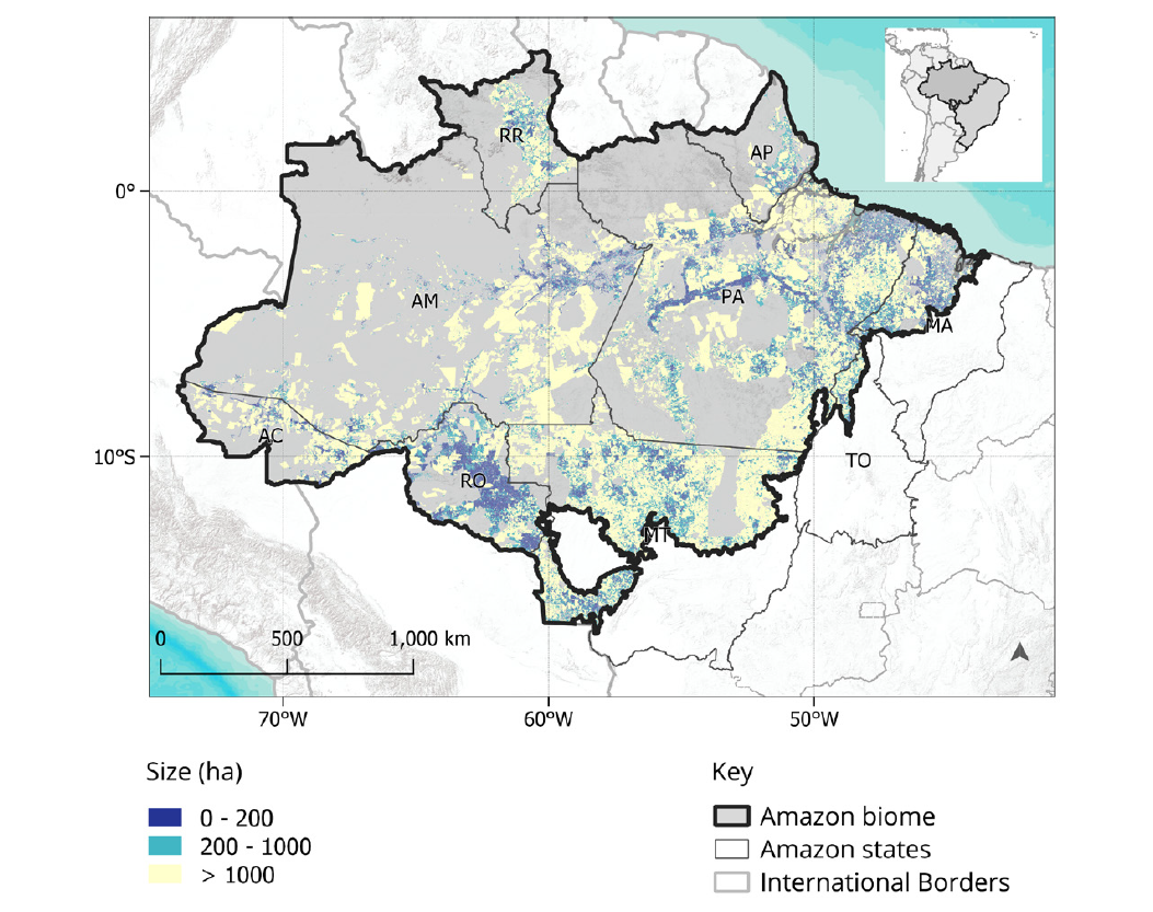
Figure 1: Rural properties and land-reform settlements in the Amazon biome. Prepared by the authors using INCRA and CAR/SFB data.
Figure 1 organizes private properties and land-reform settlements in the Amazon biome by size class. The largest concentrations of small properties (less than 200 ha) are in Rondônia, on the Pará portion of the Transamazônica highway, in the Bragantina area (PA), and the Maranhão portion of the biome. Most of them were settled by the 2000s. In the vicinity of the Xingu park, in Northern Mato Grosso, in Southern Pará, Southeastern Amazonas, and along the BR-163 highway, mid-size (200 to 1000 ha) and large (more than 1000 ha) properties predominate. These are areas of more recent occupation.
TRENDS IN LEGAL AND ILLEGAL DEFORESTATION
Based on the data described above, we used four rules to measure legal and illegal deforestation from 2008 to 2021: (a) forest clearing in fully protected areas is illegal; (b) clearing private land outside legal reserves is legal; (c) clearing private land within legal reserves is deemed illegal; and (d) land-reform settlements are taken as single properties for legal reserve calculation purposes. We measured illegal deforestation by comparing property details with deforestation maps. We used PRODES/INPE data to calculate each property's primary forest portion and then found to what extent each had been legally or illegally cleared.
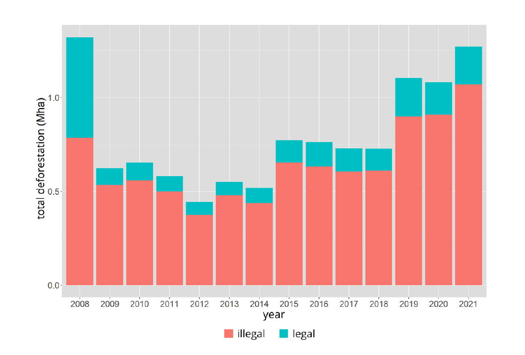
Figure 2: Legal and illegal deforestation on Amazon biome properties. Prepared by the authors using CAR/SFB, FUNAI, ICMBio, INPEdata.
Figure 2 shows total legal and illegal deforestation between 2008 and 2021. Except for 2008, the proportion of illegal clearing ranges from 81% to 87%. Figures from 2008 reflect the amnesty granted under the Forestry Code for areas cleared earlier. The proportion of legal deforestation follows three trends. Robust government action against deforestation from 2009 to 2014 drove down the proportion of legal deforestation, indicating that farmers reacted to command and control actions. The proportion of legal deforestation grew in 2015 and remained relatively stable until 2018. Illegal and legal deforestation increased from 2019 to 2021 because of virtually no enforcement during the Bolsonaro administration. Thus, the data suggest that legal and illegal deforestation respond to government control actions.
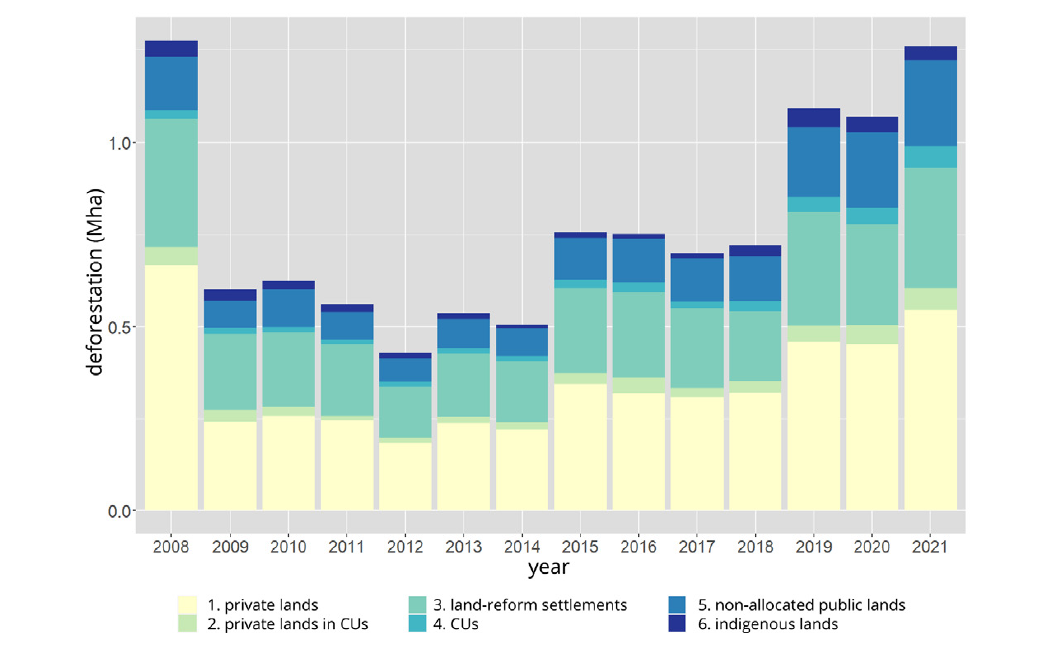
Figure 3: Total deforestation by type of land ownership. Prepared by the authors using CAR/SFB, FUNAI, ICMBio, and INPEdata.
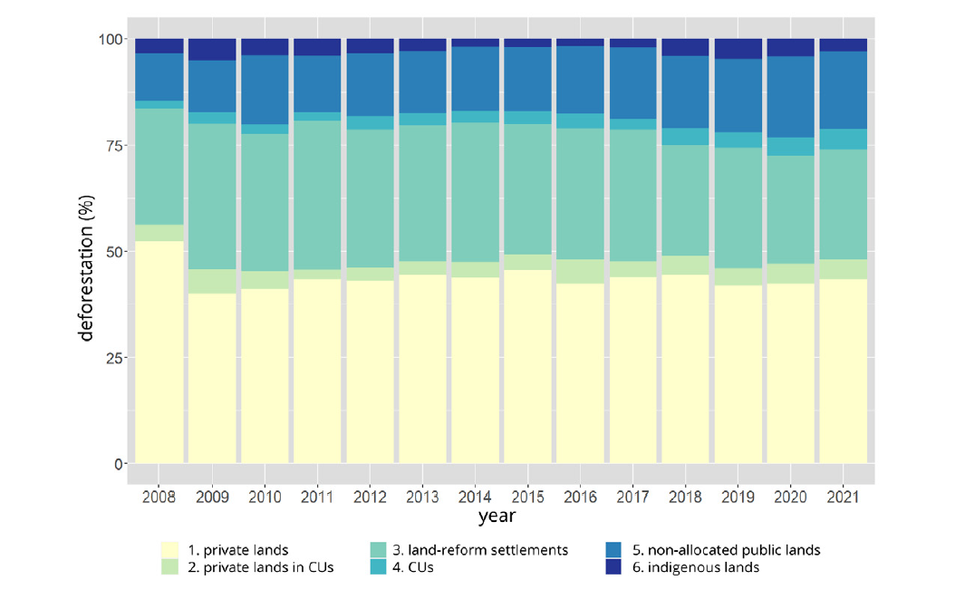
Figure 4: Relative deforestation by type of land ownership. Prepared by the authors using CAR/SFB, FUNAI, ICMBio, and INPE data.
We also calculated the extent of deforestation from 2008 to 2021 by type of land use for private lands, land-reform settlements, conservation units, indigenous lands, and non-allocated public lands. Figure 3 shows total deforestation by type of land use, and Figure 4 illustrates the relative variation. The data shows that some 50% of forest clearing occurs on private land and that clearing on land-reform settlements decreased from 30% in 2008-2012 to 25% of the total in recent years. Deforestation on non-allocated public land increased from 12% in 2008 to 20% in 2021. The latter increase is a critical sign that the land frontier is being pushed into new areas outside the traditional "deforestation arc" (Azevedo-Ramos et al. 2020).
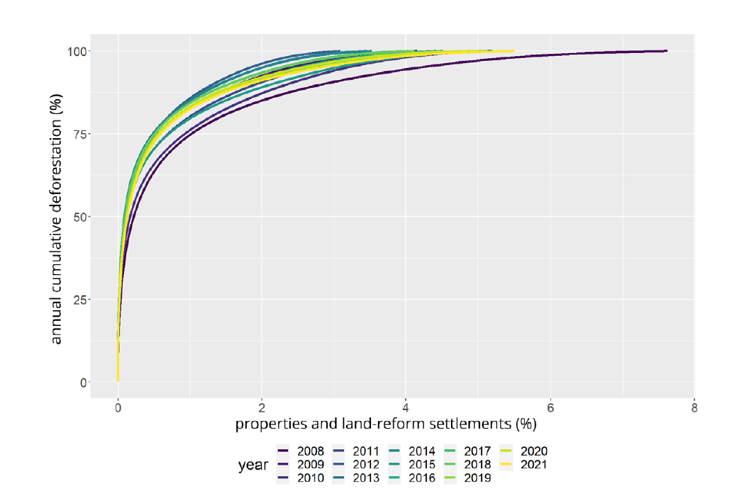
Figure 5: Accumulated deforestation from most to less deforested property types. Prepared by the authors using INCRA, CAR/SFB, and INPEdata.
Figure 5 shows the cumulative distribution of deforestation in properties and land-reform settlements. We ranked properties from most to less deforested annually to make that chart. It excludes forest clearing in non-allocated public lands, conservation units, and indigenous lands, which account for 20% to 25% of total annual deforestation. We found an extreme instance of Pareto's Law, where few elements cause most effects. In general, only about 5% of properties and settlements are responsible for 100% of deforestation each year within CAR areas.
During the robust government action period of 2008-2012, 75% of deforestation occurred in about 1% of properties. In 2018-2021, when enforcement actions were very limited, 75% of deforestation occurred in about 0.5% of properties. In other words, only 2,500 properties and land-reform settlements out of a total of 500,000 concentrated most of the deforestation in recent years, so forest clearing is strongly concentrated in a few players responsible for large-scale clearings. That suggests that targeted control actions may have a strong effect on preventing illegal deforestation.
Given that a small fraction of properties and settlements is responsible for most of the deforestation, their geographic distribution is significant. Figure 6 shows the location of all properties and land-reform settlements included in the CAR, highlighting the 1% of titled land in the Amazon that accounts for 83% of deforestation on said property groups in 2021.
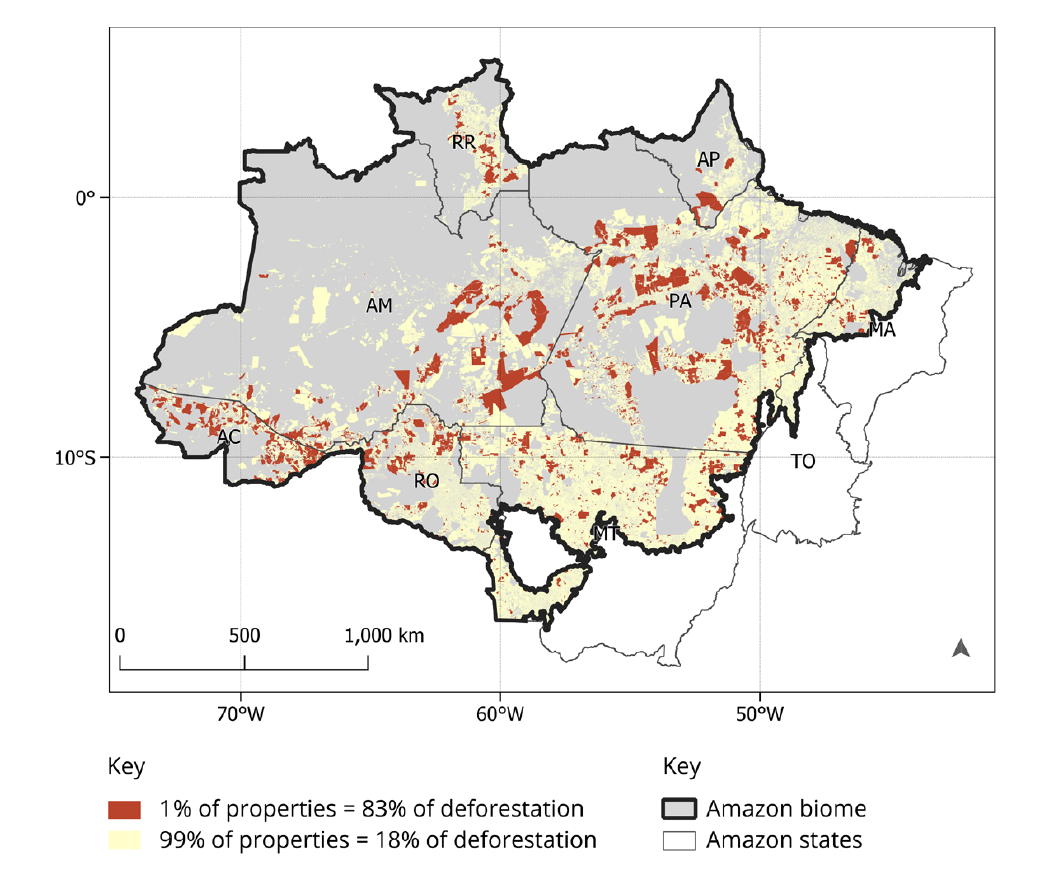
Figure 6: Geographic location of rural properties in the Amazon, highlighting 5,054 properties (1% of total) responsible for 83% of deforestation in CAR areas in 2021. Prepared by the authors using CAR/SFB, FUNAI, ICMBio, and INPE data.
LEGAL RESERVE DEFICITS AND SURPLUSES
The calculation of legal reserve deficits and surpluses in the Amazon biome must consider the exceptions in the Forestry Code reducing that reserve to 50% of the property solely for recomposition purposes. Those circumstances include: (a) properties in municipalities whose territory is more than 50% covered by conservation units and indigenous lands (article 12, para. 4); and (b) properties in reduced-reserve areas pursuant to state Ecological-Economic Zoning (ZEE) rules (article 13, item I). Said properties must restore their legal reserves to the percentages existing in 2008, provided that no less than 50%. For example, a property with 40% legal reserve in 2008 must recompose 10% of its area to native forest. By late 2022, only three states (Acre, Rondônia and Pará) had enacted legislation reducing the legal reserve to 50% in part of their territory. This study considers the ZEEs for those states and the states of Maranhão and Tocantins, also available in Siageo Amazônia (EMBRAPA 2022).
Article 12, para. 5, specified a third circumstance where the legal reserve is reduced from 80% to 50%: when protected areas and indigenous lands cover more than 65% of state territory.
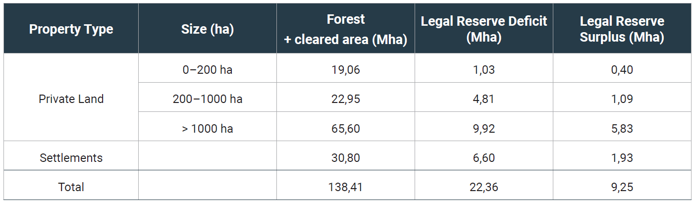
Table 2: Total forest and cleared area by property size and type, and legal reserve deficits and surpluses. Prepared by the authors using INCRA, CAR/SFB, ICMBio, INPE, and EMBRAPA data.
Table 2 shows accumulated deficits and surpluses by property size and for land-reform settlements. Legal reserve deficits in the Amazon biome add to 22.36 Mha, and the surpluses available for trade in the environmental credit market total 9.25 Mha. In general terms, full compliance with the Forestry Code will require restoring 13.11 Mha to tropical forest. In theory, compliance with its legislation will allow Brazil to meet the restoration commitments established in its NDC. In practice, a number of considerable hurdles impede compliance. Understanding those challenges requires looking at the opportunity cost associated with land use in deforested areas, which we will examine below.
In practice, a number of considerable hurdles impede compliance. Understanding those challenges requires looking at the opportunity cost associated with land use in deforested areas…
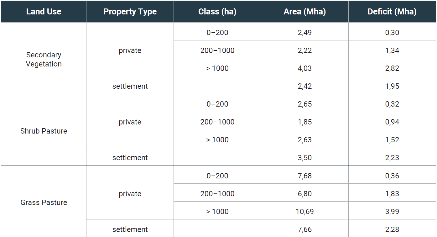
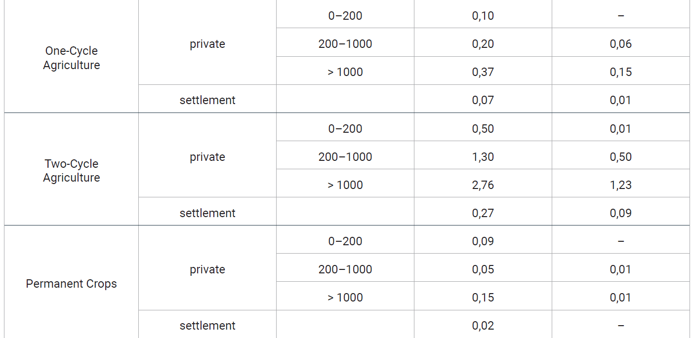
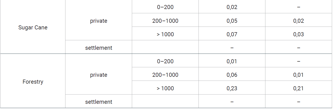
Table 3: Types of land use in deforested areas in the Amazon biome in 2020, with associated areas and corresponding legal reserve deficits. Prepared by the authors using INCRA, CAR/SFB, ICMBio, INPE, EMBRAPA data.
We calculated legal reserve deficits associated with each type of land use based on 2020 data from the land use map of deforested areas (TerraClass) created by INPE and EMBRAPA (Almeida et al. 2016). The land use classes identified in TerraClass include: (a) forestry; (b) one- and two-cycle temporary agriculture, mainly related to one-cycle soybean cultivation or intercropped with corn or cotton; (c) permanent crops such as coffee and cocoa; (d) sugar cane; (e) grass pasture (cultivated with grasses); (f) shrub pasture (pasture with the presence of woody vegetation in addition to grasses); and (g) secondary vegetation (felled forest areas in the process of regeneration).
Table 3 shows areas by types of use and related deficits. For deficit calculation purposes, we considered a hierarchy of restoration opportunity costs in reverse order of the classes identified in TerraClass (see above). Our assumption is that landowners in a legal reserve deficit position will seek to offset their obligations through alternatives entailing lower to higher opportunity costs: initially using any secondary vegetation areas, then restoring shrub pastures, then grass pastures and, finally, agricultural land.
One of the benefits of TerraClass mapping is its ability to distinguish grass from shrub pastures. The former are areas where owners invested in sowing and maintaining exogenous grasses that allow for greater herd stocking and productivity rates. Shrub pastures are associated with smaller and less productive herds.
Our results show that secondary vegetation areas are those that can most easily be used for restoration purposes. The 11.16 Mha in that category is almost enough to cover Brazil's NDC commitment. But only 3.62 Mha of those areas correspond to legal reserve deficits with restoration obligations, which means that most secondary vegetation may be cleared legally. Using those areas as a basis for restoration will require a balanced set of incentives and agreements with their owners. If feasible, their restoration will be the lowest opportunity cost alternative to achieve Brazil's NDC goal.
Secondary vegetation refers to forest regeneration in abandoned and degraded land or pastures. The literature shows that secondary vegetation areas are temporary (Picoli et al. 2020; Tyukavina et al. 2017; Richards 2015; Miranda et al. 2019). Forest in frontier areas is felled by land-grabbers (Schielein & Borner 2018, Azevedo-Ramos et al. 2020), speculators who obtain temporary land titles, sometimes issued improperly. They sell the land to farmers when prices allow them to turn a profit (Azevedo-Ramos et al. 2020). The forest can regenerate if those cleared areas are not used for agriculture for over three years. Once the land is sold, the secondary vegetation is again cleared. The secondary vegetation that appears on land left idle will also be cleared when that land is put to agricultural use (Picoli et al. 2020). Those facts indicate that CAR records must be urgently certified to verify properties’ compliance with secondary vegetation areas.
With regard to livestock farming, grass pasture areas (90% or more of grasses) total 32.83 Mha, mostly associated with herds on mid-size and large properties. Some 26% of those areas (8.47 Mha) show legal reserve deficits and should be restored. That represents a substantial challenge. On the one hand, the government's non-enforcement of the Code in relation to a legal reserve deficit of that magnitude could convey the message that the government is willing to tolerate non-compliance. On the other hand, those landowners have strong political presences in the region and in Brasília and will certainly push for incentives and payments for environmental services associated with restoration. The practical implication of full compliance with the Code will be a 35% increase in the beef cattle herd stocking rate in the Amazon. The magnitude of such a productive transformation cannot be underestimated. It will be difficult to achieve without rural credit policies associated with compliance with the Forestry Code.
Shrub pastures occupy a much smaller total area than grass pastures (10.63 Mha) and compliance with the Code will require the restoration of almost half the shrub pasture areas (5.03 Mha). The shrub pasture area in small properties and in land-reform settlements totals 6.15 Mha, of which 2.55 Mha (41.5%) correspond to legal reserve deficits. It will be wise to create a special regime attuned to the peculiarities of those landowners: they are underfunded and earn lower incomes than large cattle farmers.
Most of the land used for one- and two-cycle agricultural activities (4.63 Mha) is in mid-size and large properties with an associated deficit of 1.93 Mha (41.7%). Those are capitalized farmers who own high-value land (Spera et al. 2014, Picoli et al. 2020) and have the wherewithal to buy environmental reserve credits in the biome. The percentage of non-compliance with the Forestry Code is significant and any public policy targeting those landowners should be carefully designed. As in the case of grass pastures, if owners of land used to grow grain do not restore their legal reserves or buy environmental reserve credits, the government will find it difficult to cause other landowners to comply.
CONCLUSIONS
This paper used the most recent information available on deforestation, land ownership and use in the Amazon biome to quantify the prospects and challenges of Forestry Code enforcement. On the positive side, the strong concentration of recent forest felling in a small number of properties suggests that a focused and efficient oversight and enforcement effort may suffice for Brazil to meet the zero illegal deforestation goal in its NDC.
This paper used the most recent information available on deforestation, land ownership and use in the Amazon biome to quantify the prospects and challenges of Forestry Code enforcement. (...) Our findings indicate that relying on forest restoration in the Amazon for Brazil to satisfy the corresponding NDC item involves major challenges…
Our findings indicate that relying on forest restoration in the Amazon for Brazil to satisfy the corresponding NDC item involves major challenges associated mainly with the reaction of large and mid-size landowners of grass pastures. Our findings also differ from earlier estimates that found large degraded pasture areas in the Amazon and therefore projected a relatively low opportunity cost to comply with the Forestry Code. In contrast, we calculated at 8.5 Mha the legal reserve deficit associated with grass pastures. Any compliance drive focused on those well-funded mid-size and large landowners will involve difficult negotiations.
The second hurdle concerns mid-size and large grain farmers engaged in one- and two-cycle agricultural activities. Those farmers own high-quality land in which they have made significant investments. Regarding non-compliance with the Code, those areas show a 43.9% deficit. If the government cannot find a viable solution to cause their compliance, it will have trouble making other landowners comply.
Land-reform settlements, small and mid-sized properties on secondary vegetation and shrub pasture areas total 15.13 Mha, of which 7.11 Mha (47%) are associated with legal reserve deficits. The government may circumvent the aforementioned difficulty in imposing forest restoration through an active policy of paying small and mid-size farmers for environmental services if they fully restore their secondary vegetation and shrub pasture areas. The challenge here is adjusting payments to cover the associated opportunity costs and maintain strict enforcement in the relevant areas to avoid improprieties.
In summary, the Brazilian government faces a major challenge in implementing the Forestry Code and NDC restoration goals in the Amazon biome. The opportunity costs for large and mid-size landowners to restore the forest are significant. Those landowners are politically strong and will certainly react to unilateral actions to force them to comply with the Forestry Code without financial compensation or targeted rural credit policies.
The Brazilian government currently has a substantial capacity to collect and analyze information on Forestry Code interests. Satellite environmental monitoring systems are highly sophisticated and capable. A focused intelligence effort involving experts and good algorithms to "clean up" CAR data will produce a reliable land database. Brazil has the ability to combine the large amount of data available with high-level studies in support of public policies. That indicates that many of the technical elements needed to implement the Forestry Code and the NDC are available. The great challenge lies in designing public policies conducive to achieving Brazilian commitments under the Paris Agreement.
Acknowledgements
This work was partially funded by the International Climate Initiative (IKI) of Germany's Ministry for the Environment, Nature Conservation and Nuclear Safety, through grant 17-III-084-Global-A-RESTORE+. It was also supported by the Amazon Fund, through BNDES/Funcate agreement 17.2.0536.1 (project "Monitoring Brazilian Biomes"). Additional funding was provided by Microsoft, the Group on Earth Observations and Instituto Clima e Sociedade. The European Commission also contributed through the Horizon Europe program, funded by the "Open Earth Monitor'' project (grant no. 101059548). The TerraClass project (INPE/EMBRAPA) is supported by the World Bank and by the Amazon Protection System Management and Operations Center (Censipam). The PRODES system is funded by the Brazilian Government's Ministry of Science and Technology through action 20V9 (Monitoring the Brazilian Biomes Budget), with additional support from the National Council for Scientific Development (CNPq) through proceeding 444418/2018- 0.
[1] Settlements established by fugitive slaves in the Colonial period. Their descendants had land claims legally recognized in 2018.
References
Almeida, C., A. Coutinho, J. Esquerdo, M. Adami, A. Venturieri, C. Diniz, N. Dessay,
Foreign Durieux, & A. Gomes. 2016. “High Spatial Resolution Land Use and Land Cover Mapping of the Brazilian Legal Amazon in 2008 Using Landsat-5/TM and MODIS Data.” Acta Amazonica 46 (3): 291–302. https://doi.org/10.1590/1809-4392201505504.
Azevedo-Ramos, C., P. Moutinho, V. Foreign d. S. Arruda, M. C. C. Stabile, A. Alencar, Castro, & J. Pg. Ribeiro. 2020. “Lawless Land in No Man’s Land: The Undesignated Public Forests in the Brazilian Amazon.” Land Use Policy 99, 104863. https://doi.org/10.1016/j.landusepol.2020.104863.
Charivari, J., C. Foreign Lopes & J. N. de Araujo. 2021. Onde estamos na implementação do Código Florestal? Radiografia do CAR e do PRA nos estados brasileiros. 2021 Issue. Technical Report. Rio de Janeiro: Climate Policy Initiative/PUC-Rio. https://www.inputbrasil.org/wp-content/uploads/2021/12/REL-WEB-Onde-Estamos-2021.pdf.
CSR. 2022. Panorama do Código Florestal Brasileiro. Technical Report. Centro de Sensoriamento Remoto, Minas Gerais Federal University (UFMG). https://csr.ufmg.br/radiografia_do_cf/wp-content/uploads/2022/11/policy_brief_pt_final.pdf.
Dias-Filho, M. & C. Andrade. 2019. Recuperação de Pastagens Degradadas na Amazônia. Brasília: EMBRAPA. http://dx.doi.org/10.13140/RG.2.1.1854.5761.
EMBRAPA. 2022. Siageo Amazônia (Sistema Interativo de Análise Geoespacial da Amazônia Legal). Database. https://www.amazonia.cnptia.embrapa.br/.
Guidotti, V., S. Ferraz, L. Pinto, G. Sparovek, R. Taniwaki, L. Garcia, & P. Brancalion. 2020. “Changes in Brazil’s Forest Code Can Erode the Potential of Riparian Buffers to Supply Watershed Services.” Land Use Policy 94: 104511. https://doi.org/10.1016/j.landusepol.2020.104511.
INPE. 2022. Projeto de Monitoramento do Desmatamento da Amazônia (PRODES). Database. Instituto Nacional de Pesquisas Espaciais (INPE), Brasil. http://terrabrasilis.dpi.inpe.br/.
Igari, A., A. Brites, A. Pg. Valdiones, B. Junior, B. Salgado, et al. 2021. O Avanço da implementação do Código Florestal no Brasil. Technical Report. Observatório do Código Florestal. https://ipam.org.br/wp-content/uploads/2021/12/O-avanco-da-implementacao-do-Codigo-Florestal-no-Brasil-IPAM_V11-1-1.pdf.
Miranda, J., J. Borner, M. Kalkuhl, & B. Soares-Filho. 2019. “Land Speculation and Conservation Policy Leakage in Brazil.” Environmental Research Letters 14: 045006https://www.doi.org/10.1088/1748-9326/ab003a.
Picoli, M., A. Rorato, P. Leitão, G. Câmara, A. Maciel, P. Hostert, & I. Sanches. 2020. “Impacts of Public and Private Sector Policies on Soybean and Pasture Expansion in Mato Grosso—Brazil from 2001 to 2017.” Land 9 (1): 20. https://doi.org/10.3390/land9010020.
Rajão, R., B. Soares-Filho, F. Nunes, J. Börner, L. Machado, D. Assis, A. Oliveira, Foreign Pinto, V. Ribeiro, L. Rausch, H. Gibbs, & D. Figueira. 2020. “The Rotten Apples of Brazil’s Agribusiness.” Science 369 (6501): 246–248. https://doi.org/10.1126/science.aba6646.
Richards, P. 2015. “What Drives Indirect Land Use Change? How Brazil’s Agriculture Sector Influences Frontier Deforestation.” Annals of the Association of American Geographers 105 (5): 1026–1040. https://doi.org/10.1080%2F00045608.2015.1060924.
Schielein, J. & J. Borner. 2018. “Recent Transformations of Land-use and Land-cover Dynamics across Different Deforestation Frontiers in the Brazilian Amazon.” Land Use Policy 76: 81–94. https://doi.org/10.1016/j.landusepol.2018.04.052.
Soares-Filho, B., R. Rajao, M. Macedo, A. Carneiro, W. Costa, M. Coe, H. Rodrigues, & A. Alencar. 2014. “Cracking Brazil’s Forest Code.” Science 344 (6182), 363–364. https://doi.org/10.1126/science.1246663.
Soterroni, A. C., A. Mosnier, A. Carvalho, G. Câmara, M. Obersteiner, P. R. Andrade, R. Souza, R. Brock, J. Pirker, F. Kraxner, P. Havlik, V. Kapos, E. Ermgassen, H. Valin, & F. M. Ramos. 2018. “Future Environmental and Agricultural Impacts of Brazil’s Forest Code.” Environmental Research Letters 13 (7), 074021. https://doi.org/10.1088/1748-9326/aaccbb.
Souza, C., J. Shimbo, M. Rosa, L. Parente, A. Alencar, B. Rudorff, H. Hasenack, M. Matsuoto, L. Ferreira, P. W. Souza-Filho, S. de Oliveira, W. Rocha, A. Fonseca, C. Marques, C. Diniz, D. Costa, D. Monteiro, E. Rosa, E. Vélez-Martin, E. Weber, F. Lenti, F. Paternost, F. Pareyn, J. See Siqueira, J. Foreign Viera, L. C. Neto, M. Saraiva, M. H. Sales, M. Salgado, R. Vasconcelos, S. Galano, V. Mesquita, & T. Azevedo. 2020. “Reconstructing Three Decades of Land Use and Land Cover Changes in Brazilian Biomes with Landsat Archive and Earth Engine.” Remote Sensing 12 (17): 2735. http://dx.doi.org/10.3390/rs12172735.
Spera, S, A. Cohn, L. VanWey, J. Mustard, B. Rudorff, J. Risso, & M. Adami. 2014. “Recent Cropping Frequency, Expansion, and Abandonment in Mato Grosso, Brazil, had Selective Land Characteristics.” Environmental Research Letters 9 (6): 064010. https://doi.org/10.1088/1748-9326/9/6/064010.
Stabile, M., A. Guimarães, D. Silva, V. Ribeiro, M. Macedo, M. Coe, E. Pinto, P. Moutinho, & A. Alencar. 2020. “Solving Brazil’s Land Use Puzzle: Increasing Production and Slowing Amazon Deforestation”. Land Use Policy 91: 104362. https://doi.org/10.1016/j.landusepol.2019.104362.
Townsend, C., N. Costa & R. Pereira. 2009. Aspectos econômicos da recuperação de pastagens na Amazônia Brasileira. Technical Report. Porto Velho, RO: EMBRAPA Rondônia. https://ainfo.cnptia.embrapa.br/digital/bitstream/CPAF-RO-2010/14552/1/131-pastagem.pdf.
Tyukavina, A., M. C. Hansen, P. See Potapov, S. See Stehman, K. Smith-Rodriguez, C. Okpa, & R. Aguilar. 2017. “Types and Rates of Forest Disturbance in Brazilian Legal Amazon, 2000–2013.” Science Advances 3 (4): e1601047. https://doi.org/10.1126/sciadv.1601047.
Submitted: November 27, 2022
Accepted for publication: November 28, 2022
Copyright © 2023 CEBRI-Journal. This is an Open Access article distributed under the terms of the Creative Commons Attribution License, which permits unrestricted use, distribution, and reproduction in any medium, provided the original article is properly cited.
